


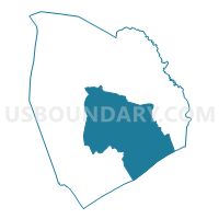
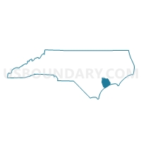
Voting District JA01, Onslow County, North Carolina
About
Outline

Summary
| Unique Area Identifier | 641033 |
| Name | Voting District JA01 |
| County | Onslow County |
| State | North Carolina |
| Area (square miles) | 201.87 |
| Land Area (square miles) | 135.19 |
| Water Area (square miles) | 66.68 |
| % of Land Area | 66.97 |
| % of Water Area | 33.03 |
| Latitude of the Internal Point | 34.63192000 |
| Longtitude of the Internal Point | -77.33856800 |
Maps

Graphs
Select a template below for downloading or customizing gragh for Voting District JA01, Onslow County, North Carolina


Neighbors
Neighoring Voting District (by Name) Neighboring Voting District on the Map
- Voting District BC21, Onslow County, NC
- Voting District BM08, Onslow County, NC
- Voting District CR07, Onslow County, NC
- Voting District EN03, Onslow County, NC
- Voting District FS16, Onslow County, NC
- Voting District HN14, Onslow County, NC
- Voting District HR17, Onslow County, NC
- Voting District HU20, Onslow County, NC
- Voting District NE22, Onslow County, NC
- Voting District NR02, Onslow County, NC
- Voting District SF18, Onslow County, NC
- Voting District SW19, Onslow County, NC
- Voting District TL06, Onslow County, NC
- Voting District VR15, Onslow County, NC
- Voting District WN04, Onslow County, NC
Top 10 Neighboring County Subdivision (by Population) Neighboring County Subdivision on the Map
- Jacksonville township, Onslow County, NC (70,537)
- Camp Lejeune UT, Onslow County, NC (29,111)
- White Oak township, Onslow County, NC (20,751)
- Swansboro township, Onslow County, NC (19,417)
- Stump Sound township, Onslow County, NC (17,336)
Top 10 Neighboring Place (by Population) Neighboring Place on the Map
Top 10 Neighboring Unified School District (by Population) Neighboring Unified School District on the Map
Top 10 Neighboring State Legislative District Lower Chamber (by Population) Neighboring State Legislative District Lower Chamber on the Map
- State House District 14, NC (84,004)
- State House District 4, NC (82,523)
- State House District 15, NC (69,750)
Top 10 Neighboring State Legislative District Upper Chamber (by Population) Neighboring State Legislative District Upper Chamber on the Map
Top 10 Neighboring 111th Congressional District (by Population) Neighboring 111th Congressional District on the Map
Top 10 Neighboring Census Tract (by Population) Neighboring Census Tract on the Map
- Census Tract 6, Onslow County, NC (10,899)
- Census Tract 28, Onslow County, NC (9,692)
- Census Tract 3.02, Onslow County, NC (9,027)
- Census Tract 24, Onslow County, NC (6,283)
- Census Tract 9, Onslow County, NC (6,120)
- Census Tract 4.02, Onslow County, NC (5,540)
- Census Tract 7, Onslow County, NC (5,176)
- Census Tract 22.02, Onslow County, NC (5,081)
- Census Tract 4.01, Onslow County, NC (4,787)
- Census Tract 14, Onslow County, NC (4,672)
Top 10 Neighboring 5-Digit ZIP Code Tabulation Area (by Population) Neighboring 5-Digit ZIP Code Tabulation Area on the Map
- 28540, NC (49,252)
- 28546, NC (42,696)
- 28547, NC (21,884)
- 28539, NC (15,469)
- 28460, NC (7,652)
- 28445, NC (5,676)
- 28544, NC (5,368)
- 28543, NC (4,699)